


In something straight out of a videogame, Singapore’s Marina Bay Sands comes to life in intricate detail, in a digital simulation. People walk around on a sunny afternoon, take selfies at the Merlion, stop at hawker centres for a snack.
It isn’t a game, though. It’s an estimation of activity, based on data gathered by a digital-twin system that is studying Singapore more or less in real time.
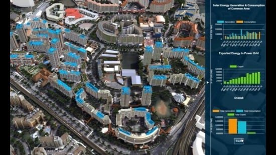
Using real data on population, use of public spaces, weather, commuting patterns and other such factors, the system can estimate real and projected traffic volumes or energy consumption, test the impact of plans for more solar panels or a new pedestrian bridge.
Data is drawn from satellites, sensors on the ground and public agencies.
Using such data, officials can also plan disaster management, study new green initiatives, and allow urban planners to rethink how a neighbourhood might be improved.
Singapore was the first country to deploy such a system on a nationwide scale, in 2017. Cities around the world are now building digital twins too, to serve as laboratories for change.
According to a 2025 report by global tech-market advisory ABI Research, over 500 cities have digital simulations serving different purposes. Some cities have more than one.
Let’s start with India. Mumbai, Pune, Chennai and Varanasi have had digital twins since 2024-25, aimed specifically at helping predict, track and tackle instances of monsoon-linked flooding.
Varanasi was the first Indian city to develop a comprehensive 3D spatial twin, integrating live surveillance and flood data in 2024. Pune followed the same year, with Mumbai and Chennai developing more complex models by 2025. (Admittedly both these cities still flood dramatically, with the key goal of improved drainage remaining unmet.)
TWIN-WIN
Around the world, infrastructure and disaster management aren’t the only missions.
In Chattanooga, Tennessee, the digital twin draws on data from traffic cameras, 911 emergency calls, radar systems and weather stations to reduce vehicular congestion, thereby improving commute times and fuel efficiency.
Australia’s project in New South Wales can now produce an online Western Sydney map of 22 million trees, with height and canopy attributes, more than 540,000 buildings, nearly 20,000 km of road and thousands of building plans, to help authorities map everything from wildfire suppression to new building applications.
Helsinki has a complex urban digital twin, designed to help study energy efficiency and support urban planning in line with the city’s emissions-reduction goals. Since 2018, the virtual twin has been used to model flood impacts on roads, assess noise pollution, map wind flows, and help position solar panels so they can make the most of the region’s less-than-abundant sunlight.
It’s a new way to manage cities, says Paul Cureton, a senior lecturer in design at University of Lancaster, and co-author of Geodesign, Urban Digital Twins, and Futures (2025). “Such simulations can even predict when a streetlight might need replacement.”
DATA CENTRES
Digital twins can be particularly helpful amid the climate crisis, because they can adapt to the problem as the problem changes, says Michael Batty, who is chairman of the Centre for Advanced Spatial Analysis at University College, London, and has worked since the 1970s on data analysis and computational models for cities.
“We are now in the era of not one but many models, many twins of the same thing,” he adds, each focused on a different area, but integrated to offer an overview.
Rotterdam in the Netherlands, for instance, has a city-wide twin within which is embedded a twin specifically for the Port of Rotterdam that looks at shipping operations and flood defences.
The real benefit may lie in the fact that digital twins enable large-scale collaboration between government departments, Cureton says. When often-siloed data sets such as transportation, energy, weather and census are brought together on a shared, accessible virtual environment, different wings of the government can simulate joint scenarios.
SOUND SYSTEMS
One concern, says Batty, is that more or less any kind of urban simulation is now being called a digital twin, and that can be counter-productive.
A software platform can only be a “twin” if the data is accurate and is being updated in real time. Accurate information is the core factor that determines whether such an effort will succeed, Cureton adds. A “twin” based on poor data could cause a downstream corruption of results, with lasting consequences for the city and its people.
The real benefit is with a nationwide rollout, he adds.
This is easier when the country is small, like Singapore. But arguably more vital when multiple systems must interlock for smooth governance.
“When urban digital twins across different geographic areas communicate with each other to form a national system,” as Cureton puts it, “that’s when you really have a larger-scale capability for resilience.”


