


Newly released high-resolution satellite images have revealed the scale of destruction caused by the recent US-Israeli strikes on multiple sites across Iran, including nuclear, military and leadership-linked facilities.According to a US Central Command (CENTCOM) fact sheet, the United States struck more than 1,250 targets in the first two days of Operation Epic Fury, saying it is hitting sites “to dismantle the Iranian regime’s security apparatus, prioritizing locations that pose an imminent threat.”
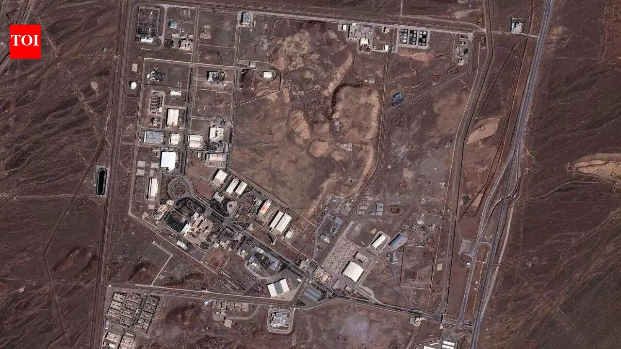
Natanz nuclear facility
Iran’s Natanz nuclear facility was among the sites hit during the latest round of US and Israeli operations, Tehran’s envoy to the UN nuclear watchdog confirmed.The United Nations’ nuclear watchdog said on Tuesday that Iran’s Natanz nuclear enrichment site sustained “some recent damage” amid the airstrike campaign, but added there was “no radiological consequence expected” from the strikes.The International Atomic Energy Agency (IAEA) said the damage was concentrated on “entrance buildings” to the underground section of the atomic site.The Institute for Science and International Security said that satellite imagery produced by Colorado-based Vantor showed two strikes on access points to the underground uranium enrichment plant at Natanz.
Satellite imagery shows damage to Iran’s Natanz nuclear complex. (Photo credit: Vantor)
David Albright, a former UN nuclear inspector and founder of the institute, said the imagery showed that three buildings at Natanz had been destroyed.According to Albright’s report, two of the destroyed structures were personnel entrances to underground halls housing thousands of centrifuges, machines used to enrich uranium for power generation or, depending on enrichment levels, weapons use. The third building reportedly covered the only vehicle access ramp to the underground halls.The report noted that although the halls were rendered inoperable by a US attack in June last year, the latest strikes could suggest that the halls still contained “recoverable centrifuges” or other related equipment.
IAEA chief Rafael Grossi told a meeting of the agency’s 35-nation board of governors that the agency had no indication that “any of the nuclear installations … have been damaged or hit.” Moments later, Iran’s representative, Najafi, told reporters outside that Natanz had been attacked.“Again they attacked Iran’s peaceful, safeguarded nuclear facilities yesterday,” Najafi said. Asked which facilities were hit, he replied: “Natanz,” before leaving.The renewed strikes come amid heightened tensions over Iran’s nuclear programme. The US and Israel have cited concerns that Iran was moving too close to being able to eventually develop a nuclear bomb, a claim Tehran has repeatedly denied, insisting its nuclear activities are for civilian purposes.
Satellite imagery shows damage to Iran’s Natanz nuclear complex on March 2. (Photo credit: Vantor)
Khamenei compound in Tehran hit
Satellite imagery also showed heavy destruction at the official residence compound of Iran’s Supreme Leader Ayatollah Ali Khamenei in Tehran following early Saturday strikes.The images show multiple collapsed buildings, extensive structural damage and a large plume of black smoke rising from the secure government complex.
Satellite image of Ayatollah Ali Khamenei’s compound in Tehran (Photo credit: Vantor)
Several key structures within the compound long used as Khamenei’s primary official residence and a hub for leadership functions appear severely damaged or destroyed.Khamenei was killed in one of the initial strikes, along with about 40 other senior Iranian officials, according to reports.Khamenei’s movements had been tracked for months by the CIA, which learned about a Saturday morning meeting at the Tehran compound that he was expected to attend, a person familiar with the matter told CBS News.
Damage at Iranian military sites
Commercial satellite imagery also showed extensive damage at multiple Iranian military installations, including air, drone and naval facilities near the strategic port city of Konarak. The images, collected by US spatial intelligence firm Vantor, showed precision strikes on hardened military infrastructure along Iran’s southeastern coast on the Gulf of Oman.
In this satellite image provided by Vantor, damaged drone buildings a the Konarak drone base (Satellite image Vantor via AP)
At Konarak airbase, satellite frames show several hardened aircraft shelters bearing dark burn marks and apparent structural damage on their roofs and surrounding areas. Adjacent operational zones also appear affected, while runway sections remain largely intact in the imagery.
Choqa Balk-e drone facility
The Choqa Balk-e drone facility in western Iran was also struck. Iran is known to deploy Shahed-136 “kamikaze” drones one-way attack drones equipped with built-in warheads that detonate upon impact.
This satellite image provided by Vantor shows after airstrikes destroyed buildings and equipment at a drone base at Choqa Balk-e facility.
Satellite images indicate significant damage at the site, which is linked to Iran’s drone production and operations.The latest wave of strikes marks a major escalation in the conflict, with US and Israeli forces targeting military, nuclear and leadership-linked infrastructure across Iran as part of Operation Epic Fury.


