


The small unit of the Ukrainian Armed Forces, stationed about 10 kilometers from the front line in the country’s southeast, knew there was something afoot in a building obscured by thick tree cover. The spring foliage hid its outline but not the signals from the electronic devices within.


The team launched a reconnaissance drone, which couldn’t see much through the trees. But the soldiers had another card to play: high-definition, near-real-time images taken by commercial satellites, delivered directly to their phones, tablets and laptops.
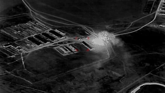
The satellite sensors showed the thick, metal frames of armored vehicles—the type used by senior Russian military officials—parked around the building. After three days of surveilling the site from orbit, the unit determined it was a Russian meeting spot for planning operations, members said. Then they struck the building and vehicles with an attack drone, one of the members said.
“It was good work,” he said. “We made problems for our enemy.”
Over the past six months, during small-team missions to test the technology, images from commercial satellites operated by Colorado-based Vantor have improved the speed and precision of Ukraine’s drone attacks. The rapid delivery to soldiers of geospatial intelligence has shortened by as much as 90% the time it takes to locate and strike Russian assets, according to the technology providers and people involved in the missions. Augmenting the images is software that lets users identify and investigate targets in detail.
In this grinding war now well into its fifth year, Ukraine continues to spark new and unexpected technology innovation that its weary military hopes might provide an edge against the Russians. After a brutal winter, Ukraine has emerged this spring with a tactical and technological advantage over Russia. Part of that is being driven by Ukraine’s improvements in midrange strikes on Russia’s logistics hubs, warehouses and air defenses. Using faster, more accurate satellite imagery to guide strikes is part of Ukraine’s strategy for launching more precise attacks from a distance.
The Ukrainian military’s deployment of the program marks the first known instance of unclassified, commercial satellite imagery going directly to a soldier to guide real-time battle decisions, according to the companies and military analysts. The same satellites used to monitor illegal fishing and update Google Maps have found a new and deadly application.
The technology is a trans-Atlantic collaboration between Vantor, Dutch geospatial intelligence company Bravo1Alpha, U.S.-based Persistent Systems and Ukrainian defense firm Burevii.
The Ukrainian involved in the strike on the Russian planning site said the new technology helps preserve Kyiv’s two scarcest assets: “It is money, it is time,” he said. With access to the satellite images, his team didn’t have to rely on surveillance drones that can be expensive and are more easily jammed or shot down by the Russians.
During a springtime mission, called Starfall II, a Ukrainian unit spent 2½ weeks destroying billions of dollars in Russian assets. Among the targets was a Russian ammunition depot in occupied Ukraine that soldiers had identified after pulling a satellite image of the structures, which had once been used to store grain, members of the team said. Comparing the new image with older photos of the property dating back to before the Russian invasion, soldiers identified changes that convinced them it was no longer an agricultural operation and spotted fresh tire tracks that were consistent with military vehicles unloading ammunition. Members of Ukraine’s Brigade 422, a midrange strike team, dispatched attack drones.
“Every ammunition depot you destroy is at least a couple of Ukrainian soldiers’ lives you save,” said one member of the operation, a technical adviser assisting the armed forces.
The satellite intelligence has allowed them to do within hours what used to require weeks, either because of a lag in getting intelligence out to the front, or the relative slowness of launching a drone and waiting for it to survey large areas, often made slower by fog or snow.
“Compressing the sensor-to-shooter cycle is the defining trend of this war at the tactical level,” said Franz-Stefan Gady, a military analyst and founder of defense advisory firm Gady Consulting.
As with every technology, satellites have their limitations: They are not particularly helpful on days of thick cloud cover, which is much of the winter in Ukraine, and can’t loiter over a moving target.
Satellite imagery itself is nothing new in war. Commercial and government satellite operators have long been key intelligence sources. Vantor published satellite images of Russian tanks and troops in position near the border of Ukraine before the war began. Ukraine has been heavily dependent on U.S. intelligence sources to conduct strikes.
Vantor’s push into defense helped it reach $900 million in annual recurring revenue last year, when the company, which is owned by private equity, also added more than 10 European defense and intelligence customers. Part of what those agencies are seeking, Vantor said, is the capability now being used by Ukraine.
Vantor’s images go directly from the satellite to the soldier’s tablet, phone or laptop in as little as 15 minutes, bypassing a centralized review in Kyiv that has tended to slow down the flow of intelligence to the front line by hours or days.
One Ukrainian fighter said intelligence received from human sources on the location of Russian targets required at least two days of review time in Kyiv. A former soldier in Ukraine said geospatial intelligence was sometimes so stale by the time it reached the units at the front line, soldiers couldn’t act on it. Military analysts say the turf war over access to satellite images between Ukraine’s government and military branches has hindered the dissemination of intelligence.
The press office for the Armed Forces of Ukraine declined to comment. The military intelligence unit didn’t respond to a request for comment.
The Vantor software allows soldiers to compare a current satellite image with historical images, as Brigade 422 did with the ammunition depot, and see infrastructure changes or movement. Artificial intelligence monitors large areas and detects when a target shifts. The software generates 3-D renderings that soldiers can use to simulate the best flight path for a drone.
Vantor’s 10 satellites cover 7 million square kilometers of Earth a day, hitting any one point on the globe 12 to 15 times, said Will Cocos, Vantor’s chief transformation officer and a former Navy SEAL. Typically, the coordinates on Vantor’s images are within 5 meters (16 feet) of an object’s real position, plenty accurate for a 50-kilogram (110-pound) explosive, the Ukrainian users said.
Ukraine is now previewing for much of the West what’s possible when the chain of intelligence gets compressed, said intelligence analysts. U.S. Special Operations Command last year added new software to provide near-real-time commercial satellite images on soldiers’ mobile devices, a Socom spokeswoman said.
Army spokesman Maj. Sean Minton said the service doesn’t yet send satellite intelligence directly to soldiers’ devices, but is working toward it through a broader effort to create a high-speed information system that gives soldiers of all ranks access to satellite data “free from headquarters reviews.”
Removing some of these intermediaries responsible for vetting might speed things up, but it also raises the risks that soldiers get wrong information—and act on it, said Nand Mulchandani, former chief technology officer for the Central Intelligence Agency and the Defense Department’s artificial intelligence office.
“There are processes in place that slow things down, but there are processes in place for a reason,” Mulchandani said.
Write to Heather Somerville at heather.somerville@wsj.com


