



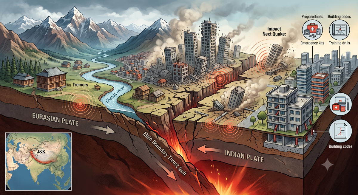
Srinagar, Jul 14: The rattling of windows, swaying ceiling fans, and hurried rush to open spaces have become familiar scenes across Jammu and Kashmir whenever the earth shakes beneath the Himalayas. From Srinagar to Doda, Kishtwar to Kupwara and Ladakh to Poonch, recurring tremors in recent years have kept residents on edge, serving as reminders that the region sits atop one of the most seismically active zones in the world.
Scientists say the reason lies deep beneath the mountains. J&K is located along the collision boundary of the Indian and Eurasian tectonic plates, where the Indian plate continues to move northwards at nearly five centimetres every year. The enormous pressure generated by this ongoing collision is periodically released through earthquakes, making the Himalayas one of the youngest and most geologically active mountain systems on Earth.
Consequently, large parts of Jammu and Kashmir and Ladakh fall under Seismic Zones IV and V under India’s seismic zoning map, with Zone V representing the highest earthquake hazard category in the country. Large swathes of Kashmir Valley, Chenab Valley and parts of Ladakh fall in the highest risk category.
Renowned earth scientist Prof Shakil Ahmad Romshoo says the Kashmir Himalaya remains among the most vulnerable regions in South Asia because of its active tectonic setting and rapidly expanding urban footprint. “The Kashmir Himalaya is among the most seismically active regions in the world due to the continued convergence of the Indian and Eurasian plates. Preparedness and strict adherence to seismic building codes are critical to reducing future losses,” Romshoo says.
According to geologists, the region is influenced by major fault systems, including the Main Boundary Thrust, Main Central Thrust and several local fault lines that continue to accumulate stress beneath the surface. The scars of the devastating October 8, 2005, earthquake continue to haunt the region.
The magnitude 7.6 earthquake, with its epicentre near Muzaffarabad, killed more than 80,000 people across the region and left widespread destruction in Uri, Tangdhar and several border areas of north Kashmir. Entire villages were flattened within seconds, and thousands were left homeless.
Nearly two decades later, scientists warn that the Himalayan arc remains capable of producing earthquakes of similar or even greater intensity. This year alone, a magnitude 4.7 earthquake struck Baramulla district in February, while another 4.2 magnitude tremor jolted Doda district in March.
Earlier this month, a moderate earthquake near Padam in Kargil district also triggered concern among residents, although no damage was reported. Tremors originating in Afghanistan’s Hindu Kush region are also frequently felt across Jammu and Kashmir due to the region’s geological setting.
A recent study co-authored by Romshoo on Srinagar’s built environment warned that large sections of the city are highly vulnerable to earthquake damage because of dense habitation, soil characteristics and inadequate compliance with seismic safety standards in many structures. The researchers recommended strict enforcement of building codes, retrofitting of vulnerable buildings and scientific urban planning to reduce disaster risks.
Experts, however, caution against complacency. “There is a misconception that frequent small earthquakes release pressure and reduce the likelihood of larger events. Scientifically, that is not true. Small tremors do not rule out the possibility of a major earthquake,” says independent weatherman Faizan Arif.
Experts point out that traditional Kashmiri architecture, particularly the timber-laced Dhajji Dewari construction technique, had historically shown remarkable resilience during earthquakes. However, these structures are increasingly being replaced by reinforced concrete buildings, many of which are constructed without adequate seismic safeguards.
Veteran meteorologist and Director Meteorological Centre Leh, Sonam Lotus, says preparedness rather than prediction remains the only defence against earthquakes.
“Unlike weather systems, earthquakes do not provide advance warning. Preparedness, resilient infrastructure and public awareness remain our strongest tools to minimise losses,” Lotus says.
He notes that Himalayan regions are increasingly exposed to multiple hazards, including earthquakes, cloudbursts, flash floods and landslides, making disaster preparedness an essential part of life in the mountains.
Recent cloudburst in Pahalgam, landslides in Kishtwar and extreme weather events across the region have highlighted the growing vulnerability of the fragile Himalayan ecosystem to multiple and overlapping hazards. For the people of Jammu and Kashmir, the mountains may symbolise permanence and stability. Yet beneath the snow-covered peaks and picturesque valleys, the earth continues to move silently. The question facing Jammu and Kashmir is not whether another major earthquake will strike. It is whether the region will be prepared when the mountains move again.


