


")


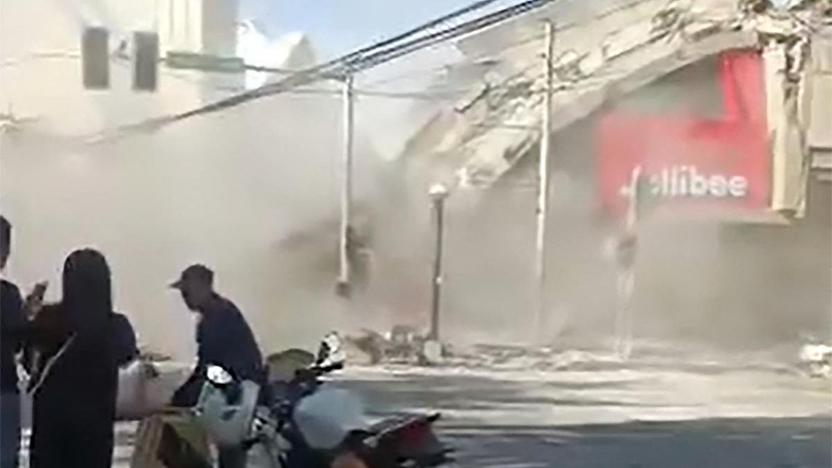
An offshore magnitude 7.8 earthquake rocked the southern Philippines early on Monday (June 8, 2026), damaging buildings and a key access bridge in a large southern city and setting off a 1-metre (3-foot) tsunami that washed ashore on nearby coasts.
The death toll has reached at least 15, with more than 100 people injured, disaster agency officials said. Twelve people were killed in the Soccksargen region of Mindanao island, regional civil defence director Rodrigo Sosmena said, adding 129 people had been injured there.
Three more fatalities were recorded in Davao Occidental Province.
President Ferdinand Marcos Jr. urged people to immediately go to higher ground in Philippine areas vulnerable to a tsunami, and Indonesian and Malaysian authorities also issued warnings to their nearby coastal areas.
The strongest quake to strike the Philippines this year was centred at sea about 13 km southwest of General Santos, a city of more than 700,000 people that is a hub for tuna processing and other commerce in the southern Mindanao region of the archipelago nation.
The Philippine leader said disaster-response agencies were on standby to respond. “The national government is moving, and we will not leave Mindanao behind,” Mr. Marcos said.
Numerous aftershocks followed the 7:37 a.m. on Monday (June 8, 2026) quake, which was felt in nearby Malaysia. Tsunami waves were also detected in Indonesia and Malaysia.
The international airport in General Santos was temporarily shut due to the earthquake, and 17 domestic flights were cancelled, civil aviation officials said.
Ednar Dayanghirang, director of the Office of Civil Defence in a nearby southern region, said more than 100 students attending morning flag-raising ceremonies sustained bruises and some fainted in panic at different grade and high schools.
“I myself could hardly stand and keep my balance when the ground shook as I was leaving my house,” Mr. Dayanghirang told the AP by telephone from southern Davao, a major port city in the southern Philippines.
DZRH radio station in Manila reported that a small commercial building housing its provincial branch partly collapsed, and staffers dashed to the ground floor without injuries. It wasn’t clear if other people were trapped in the rubble of the four-storey office building. Debris also fell from other buildings, hitting tricycle taxis parked below.
The quake was caused by movement in the Cotabato Trench at a depth of 10 km, according to the Philippine Institute of Volcanology and Seismology.
“It’s a major earthquake, and we’re expecting damage, and we’ve already seen some damaged buildings based on videos we’ve seen,” institute director Teresito Bacolcol told AP.
Tsunami waves near 3 feet measured
Waves of 1-metre (3-feet) were monitored in the Philippine Provinces of Sultan Kudarat and Sarangani by land-based tsunami watch stations, Mr. Bacolcol said. Smaller waves were monitored in at least one other Province, he said.
“Please heed the tsunami warning. Move to higher ground now. Do not wait. Your life is more important than anything left behind,” Mr. Marcos told people in quake-hit Provinces.
The Pacific Tsunami Warning Center said tsunami waves up to 3 metres (10 feet) were possible on some coasts of the Philippines. Waves up to 1 metre (3 feet) were possible on some coasts of Indonesia and Malaysia.
Malaysia’s Meteorological Department issued a tsunami warning for Sabah state on Borneo Island. Sabah is just a boat ride away from the southern Philippines. An 83-centimetre (2.7-feet) tsunami was measured by a gauge off Indonesia’s Sulawesi Island.
Smaller sea changes were possible in Japan, Papua New Guinea and several island nations and territories in the western Pacific. An advisory for Guam was lifted about two hours after the quake, and there was no threat to Hawaii, the PTWC said.
Aftershocks up to 6.5 magnitude were measured by the U.S. Geological Survey. It reported the depth of the original quake at 55 km (34 miles). Variations in measurements by different agencies are common in the immediate aftermath of an earthquake.
The Philippines, one of the world’s most disaster-prone countries, is often hit by earthquakes and volcanic eruptions due to its location on the Pacific “Ring of Fire,” an arc of seismic faults around the ocean. The archipelago is also lashed by about 20 typhoons and tropical storms each year.

Published – June 08, 2026 05:45 am IST


