


Ahead of this year’s monsoon season, the Uttarakhand government started identifying settlements vulnerable to disasters, similar to last year’s Dharali tragedy in Uttarkashi district, said Vinod Kumar Suman, secretary for Disaster Management and Rehabilitation, on Friday.

")
Suman said that the process of identifying vulnerable locations across the state has begun, particularly areas where water influx could threaten human settlements
“In the first phase, Uttarkashi, Chamoli and Pithoragarh districts have been selected for the exercise. A team from the disaster management department was sent to Chamoli district to identify sensitive locations. The district was first surveyed through satellite imagery and later through drone mapping. Based on the assessment of risks, a detailed report has been submitted to the Chamoli district administration,” he said.
He added that surveys in other districts are complete, and local administrations have been asked to carry out drone surveys at their level at the earliest.
According to officials, the assessment focuses on identifying settlements vulnerable to cloudbursts, excessive water flow in streams and rivulets, and debris flow during heavy rainfall.
“After the districts submit their reports, decisions will be made on the mitigation measures required in vulnerable areas. Wherever necessary, instruments and monitoring systems will also be installed,” Suman said.
Department also monitors the impact of water released from dams, including the extent to which the water may travel and the likely rise in water levels downstream, Suman added.
“Monitoring is being carried out through various mechanisms. Sirens have also been installed at several locations. A meeting was held with dam authorities last year and another meeting is proposed for this year. During the meeting, dam authorities will be requested to install sirens wherever required,” he said.
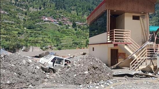
A massive mudslide struck Dharali village on August 5 last year, triggering flash floods that swept through the village. While two bodies were recovered, 67 people, including 25 Nepal nationals, remain missing.
A scientific panel constituted by the state government to ascertain the possible reasons for the tragedy said in its preliminary report in August that the Dharali flash floods were not caused by a glacial lake outburst flood (GLOF), but by intense, heavy, localised rainfall at high altitude.
Uttarakhand becomes highly vulnerable during the monsoon season due to its fragile Himalayan terrain, steep slopes, glacier-fed rivers and increasing human activity in ecologically sensitive areas.
Heavy rainfall and cloudbursts often trigger landslides, flash floods, debris flow and river erosion, especially in districts such as Chamoli, Uttarkashi and Pithoragarh.
Also Read:Joshimath disaster: Measures yet to be taken to address land subsidence issue
Unplanned construction, road cutting, deforestation and rapid urbanisation further weaken mountain slopes and obstruct natural drainage systems, increasing disaster risks during intense rainfall.
Climate change has also contributed to more erratic and extreme weather events, making the state increasingly prone to cloudbursts, floods and slope failures during the monsoon months.
On April 19, chief minister Pushkar Singh Dhami visited Dharali during his trip to Gangotri. Residents submitted a memorandum flagging that out of 116 commercial hotels, 23 have been marked as being on government land, leading to a delay in relief from the Chief Minister’s Relief Fund.
They also sought compensation for tenant shopkeepers and restaurant owners, waiver of agricultural loans, and restoration of damaged infrastructure, including the ancient Kalpkedar temple.
They also demanded land for displaced hoteliers and farmers, and immediate construction of protective walls in vulnerable stretches.


