


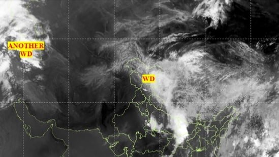
A satellite image issued by the IMD depicts a massive cloud band extending over much of North and Central India. Recent thermal infrared data from the INSAT-3DS weather satellite points to a strong development of rain-bearing weather systems across the subcontinent.

The cloud belt can be seen coming from Pakistan, covering large parts across northwest India across Punjab, Haryana, Delhi, Uttar Pradesh and parts of central India before moving over eastern India and the Bay of Bengal.
The National Capital also recorded high temperatures, crossing 45 degrees Celsius mark at various stations. However, Delhi residents got some relief on Thursday as heavy rain, thunderstorms, and gusty winds swept across parts of the city.
India Meteorological Department (IMD) has issued an orange alert for the city, warning of moderate to severe thunderstorms accompanied by lightning, dust storms and isolated hailstorms. The weather office said the current spell of rain and thunderstorm activity is expected to continue till May 31, news agency PTI reported.
North India reeling under hot temperatures
North India continues to endure intense heat as temperatures steadily rise across the region. In Uttar Pradesh, Banda emerged as the hottest location, recording a scorching 47.5 degrees Celsius, according to the weather department.
Jhansi followed with 46.5 degrees Celsius, while Orai recorded 44.8 degrees Celsius and Agra registered 43.3 degrees Celsius. Kanpur city saw temperatures reach 42.2 degrees Celsius, whereas Aligarh reported 42.8 degrees Celsius, as per IMD.
Other parts of the state also remained under severe heat conditions, with Hamirpur and Lakhimpur Kheri both recording 42.2 degrees Celsius and 42 degrees Celsius, respectively. Prayagraj registered 41 degrees Celsius, while Churk in Sonbhadra recorded 40.3 degrees Celsius.
Also Read: Expect rain, thunderstorms across J&K till June 5: IMD
In Rajasthan, Sri Ganganagar topped the list as the hottest location with 47.1 degrees Celsius. Churu recorded 46.5 degrees Celsius, followed closely by Kota and Pilani at 46.4 degrees Celsius. Alwar and Phalodi registered 46 degrees Celsius each, while Jaipur recorded 45.4 degrees Celsius. Bikaner saw a high of 45.3 degrees Celsius, Bhilwara recorded 43.7 degrees Celsius, and Ajmer registered 42.3 degrees Celsius, according to the meteorological department.
IMD issues heavy rain alert for Uttarakhand
IMD on Thursday issued a warning for Uttarakhand, predicting heavy rainfall, thunderstorms and hail in several parts of the state on Friday, as reported by PTI.
“Light to moderate rain, thunderstorms and snowfall at altitudes of 3,800 metres and above are likely at most places across the state,” IMD said in a statement.
Isolated places in Uttarkashi, Dehradun, Tehri, Rudraprayag, Chamoli, Bageshwar and Pithoragarh are likely to experience thunderstorms accompanied by lightning, hail, intense spells of rain, and gusty winds reaching speeds of 50 to 60 kmph, gusting up to 70 kmph, IMD said, PTI reported.
India to get weaker monsoon?
India is expected to get a slightly weaker monsoon at 90 per cent than previously predicted 92 per cent that the India Meteorological Department (IMD) had forecast in April.
IMD suggests that El Niño conditions may develop during the southwest monsoon, which can weaken rainfall in India. It further said that the Indian Ocean Dipole over the Indian ocean is currently neutral but may turn positive later in the season. Meanwhile, the Madden–Julian Oscillation is in an active phase, which can influence short-term rainfall patterns.
