


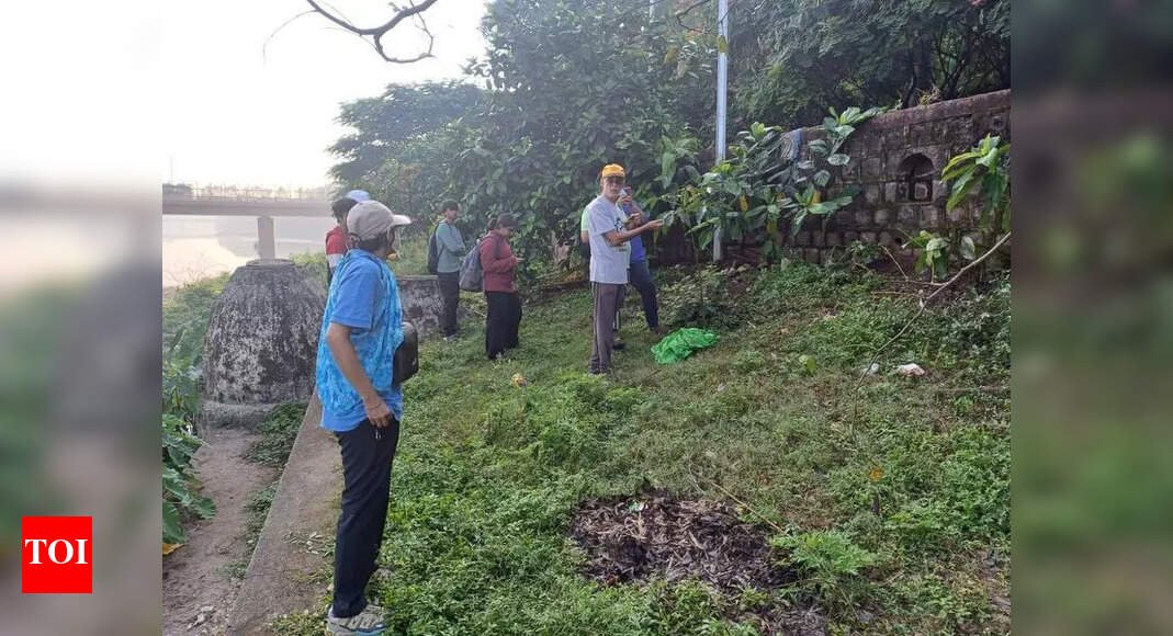
Pune: Critical data gaps have come to the fore in the official tree count done by authorities in the city. Now, a growing number of residents, conservationists and biodiversity experts have been galvanized to take mapping, monitoring and protecting existing green cover into their own hands.In the absence of a transparent and updated tree census, citizen-led geotagging initiatives are helping track species health, survival rates, and urban biodiversity across key hills, riverbanks, and forest patches in the city.On the hillsAt the Chatushrungi, Taljai and ARAI hills, members of the Green Hills Group, like Gaurav Rathi, are geotagging newly planted saplings using a custom-built app TrackMyTree by CoReCo technologies that stores species name, planting date, GPS location, height, girth and even the caretaker assigned.“We’ve geotagged 700 trees on Chatushrungi hill already. Our aim is data-driven monitoring of plant growth rates, comparing species performance, and identifying which species thrive best in different terrains,” Rathi told TOI.The scale of the initiative is growing steadily, with 50-80 volunteers participating each weekend. At Taljai hill alone, over 1,200 trees have been tagged, and at ARAI, another 700. The group’s barcode-based system ensures that every sapling planted is linked to its caretaker and location, forming the foundation for a long-term citizen science project.The need for such initiatives became glaringly evident in 2024, when over 150 residents around Taljai hill alleged that authorities had hacked trees without proper permission passes and adequate information. Protesters claimed that during the forest department drive to remove gliricidia trees on the tekdi, contractors also cut down indigenous trees.“There was no clear distinction being made. Native trees were cut indiscriminately,” said Mandar Joshi, a resident of Sinhagad Road. An FIR was lodged, but the incident underscored a deeper concern: the absence of a public, up-to-date tree database.In response, Joshi and a few other residents of Sahakarnagar also began mapping what remained of the trees on the same hill. “We started with existing paths on the hill. We began taking photos, recording GPS coordinates and putting this all up on open-source data collection portal Epicollect. Our aim was to document the native species before they vanished,” he said.Over time, they geotagged multiple trees and identified over 200 native species in the area — out of around 600-700 species found across Pune, although most remain undocumented. “These are not just trees, they form ecosystems. We saw pockets of pure native forest, untouched by non-native species. But even those are now at risk,” said Joshi.Along the riversAt the same time, Pune River Revival (PRR) — a volunteer collective of citizens aiming to conserve the city’s rivers — is meticulously documenting existing trees along the Mula river, including in biodiversity-rich areas like Pimple Nilakh and Vishalnagar.“Tree mapping activity initially started as a citizen engagement programme in Dec last year, where people were made aware about the natural heritage around them. These biodiverse green patches play a significant role in maintaining the city’s delicate ecological balance. The activity evolved over time as we documented habitats, biodiversity and fauna along the riverbanks. Participants enjoyed being with nature and learned of the close connection between the health of rivers and our society,” said Mrinal Vaidya, a PRR volunteer.For their task, PRR uses the ConnecTree tool developed by the Pune Knowledge Cluster (PKC) — a body established by the Office of Principal Scientific Adviser, Govt. of India — helping them in data collection and visualization. Supplementing the exercise is also the open data collection platform Epicollect.Participants enter tree details like species, girth, GPS location and leaf patterns, along with any other available data. The inputs are verified by PKC via experts from NGO Nisarg Sevak.New volunteers, often unfamiliar with tree taxonomy, are trained on how to take accurate measurements and input reliable data. PRR conducts tree mapping activities on weekends and covers an average of 200 trees in total on both days.Users said ConnecTree allows for mapping, tracking, and monitoring growth and health of tree saplings to enable a better survival rate. The system allows a collaborative approach between citizens, activist groups, corporates and local govt bodies to better manage tree plantations over their nurturing period.“The platform helps foster better citizen engagement and enables a collaborative approach, aimed at nurturing a sense of ownership and involvement in urban forestry initiatives among the public,” said Shirish Kanitkar, in-charge of the environment and vertical sustainability department at PKC.“Tree mapping is more than just data entry,” said Akanksha Pandey, another PRR volunteer, adding, “It’s a way to know our city’s rich and beautiful ecological biodiversity and how it affects us. It has helped increase awareness about the riparian zone in the heart of Pune. The temperature inside the dense canopy of trees during even peak summer heat in April remains many degrees lower than outside. This helps citizens understand the benefit of preserving such dense tree cover.“Shailaja Deshpande, founder of Jeevitnadi, which has been working in the river conservation sphere for several years, agreed. She told TOI, “The root cause of launching this mapping activity was to make people understand that riparian zones are unique ecosystems, where only specific species grow in natural belts of the river. Unfortunately, these zones are not protected under policy. However, they are critically important as flowing freshwater ecosystems, irrespective of urban or rural areas. These precious habitats are key for sustenance as they act as buffers to control temperature, reduce flood risks, recharge groundwater, and filter pollutants.”“At present, there is not much documentation available. So, our activity serves as a good citizen-driven science project for the benefit of Pune. More than 200 participants have joined so far and around 3.75km has been covered in five months,” added Pandey.Participant Ajay Homkar, a software architect, shared, “Tree mapping has become a part of my weekend morning routine. It’s a fantastic way to connect with rivers, trees, people and biodiversity. A lot needs to be done. We need many citizens to join efforts. This is just the beginning of a long journey towards restoration of biodiversity in urban areas and beyond.”In concrete junglesWhile some residents are taking part in geotagging to ensure better data records, others are hoping to use the data to ensure that trees they plant are looked after and survive.For instance, residents of Balewadi took it upon themselves to ensure that the saplings planted along the main stretch of Baner-Balewadi road thrive. “We lost many avenue trees when Metro work commenced. At present, there is no shade to wait on several patches along the main road. This presents difficulties for bikers and pedestrians, especially during summer,” said area resident Ameya Jagtap.“As residents of the area, not only do we find shade-less roads jarring, but the massive green cover loss because of Metro work is a major trigger. This summer, Balewadi experienced extreme temperatures. Trees are the only way to deal with it,” he added.What ties all these groups together is a shared concern — lack of official data and transparency on green cover.Taljai tree-mapping participant Joshi also criticized deficient administrative efforts. “Why should citizens be building such databases? This is govt’s job. There’s no central database, no transparency. Websites have outdated information. Institutes that should be maintaining this knowledge don’t make it public. We tried collaborating with them, but eventually, it was easier to do it ourselves. We will continue such efforts as responsible citizens to the best of our ability,” he said.WHY IS GEOTAGGING IMPORTANT?Survival Updates: It is crucial to track the growth of saplings as it helps identify which species grows favourably in a terrain, and to ensure that they remain healthyProtection: Geotagging can help prevent damage to saplings or trees threatened by illegal felling, encroachment or development projectsUrban Planning: Creating a data repository can help track the density of tree cover in urban areas, maintain a balance crucial to healthy livingVOICESCitizens have limited trust in official agencies due to inaccessible or unreliable tree data and the delays in compiling it. This has prompted them to start their own geotagging initiatives, which is great. This growing citizen-science movement focuses on both new findings and documenting the existing biodiversity. Tree counting and species tracking plays a vital role in identifying, locating, and improving sapling quality, as well as in monitoring survival of planted trees— Sathya Natarajan | Author, ‘Single Page Tree Act’Trees have so far been without identity. They have no Aadhaar card, voter ID, PAN card and thus, no agency. Without geotagging there is no address either. A tree is there today and gone tomorrow, and often, nobody is any wiser for it. So, geotagging and photographing trees are the only ways of keeping them in public memory and as a public asset. All govt agencies have failed in keeping tree records. Even census numbers are dubious. There is no other way than the ongoing citizen-led initiatives— Ameet Singh | EconomistTree mapping is an excellent exercise for the community and for the environment. Better knowledge about nature will help us care for it better. Citizens have this opportunity to learn local or scientific names of plants and understand the give-and-take relationship at the centre of a thriving ecosystem. Activities like these help us understand the importance of co-existence between primary producers and apex consumers. It is like an open, free and living learning laboratory— Arati Mhaskar | Core-member, JeevitnadiThe group I was part of for riparian zone tree mapping with PRR was sincere and enthusiastic. Mapping trees along the unique ecosystem of the Mula riverbank gave us a back-to-the-roots feeling. The participants diligently performed their tasks amid light pre-monsoon showers, irrespective of language, profession, gender and age. It was altogether an immense learning experience— Abira Ghosh | Scientific and medical writer


