



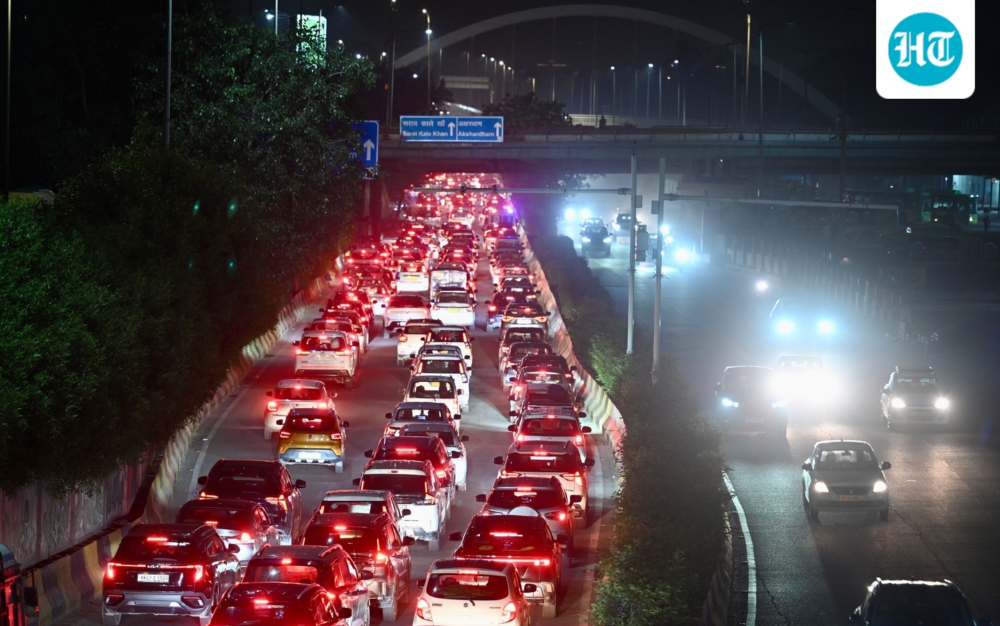
The Barapullah Phase-III flyover – meant to ease traffic between east and south Delhi – has instead, within two days of opening, created a sprawling traffic crisis across some of the Capital’s busiest roads, with traffic police forced to conduct aerial surveys which already flagged major design flaws at the points where the new corridor merges with the existing road network.

The newly opened stretch of Barapullah, connecting Mayur Vihar with the existing elevated corridor, has drawn substantial traffic volumes that would otherwise have travelled through NH-24 and the Delhi-Noida-Direct (DND) flyway, officials explained. But instead of smoothly distributing this traffic, the new corridor is funnelling large numbers of vehicles into bottlenecks where multiple lanes abruptly merge into fewer lanes, traffic police and experts said.
A drone survey conducted by Delhi Traffic Police after two days of near-continuous congestion identified two major problems, to counter which they want to introduce yet another traffic signal on the elevated corridor. If added, this would make Barapullah one of the few elevated corridors in the country needing two traffic signals to modulate traffic.
At several points, two sets of three lanes merge into a three-lane corridor, effectively forcing six lanes of traffic into three. At another point, where traffic from the new spur meets the existing Barapullah flyover on the loop over Sundial Park, a lane ends abruptly at almost a 90-degree angle, creating further conflict between vehicles.
The result has been congestion far beyond the new corridor itself, spilling onto the Ring Road, Outer Ring Road, Mathura Road, DND, Bhairon Marg and several major roads in south and southeast Delhi.
The situation worsened on Thursday, ahead of the long weekend, with traffic crawling for hours across large parts of the city.
By evening, Google Maps showed the roughly 8 km stretch between Safdarjung Hospital and Sarai Kale Khan taking more than an hour. The 5 km stretch on the Outer Ring Road between Panchsheel Park and Munirka was taking more than 35 minutes. Even the signal-free journey from the AIIMS flyover to Sarai Kale Khan via Barapullah was showing more than 45 minutes.
Also Read | Amit Shah inaugurates Barapullah flyover, 3 other road projects in Delhi
The opening has therefore exposed a basic problem: adding a new corridor does not necessarily add equivalent capacity to the road network if the traffic eventually has to squeeze through the same narrow points. In this case, the corridor has succeeded in attracting traffic, but its connections with the existing network appear unable to absorb that traffic smoothly.
“The opening of Barapullah Phase-III and the resulting changes in traffic movement have significantly affected the Ring Road and the Ashram area,” a senior traffic police officer said. The situation has been aggravated by ongoing construction at several locations, including the Modi Mill flyover, Chirag Delhi, and flyovers between South Extension and Ashram junction.
Commuters, meanwhile, were left facing dire consequences. Karan Singh, a Ghaziabad resident who regularly uses the Sarai Kale Khan route, said navigation apps showed congestion across the entire stretch and rerouted him towards Bhairon Marg. “It usually takes me around 45 minutes to reach home, but today it will take me more than two hours,” he said.
Traffic was reported through the evening across the Ring Road, Outer Ring Road, Sarai Kale Khan, Mathura Road, DND, Barapullah, Bhairon Marg, India Gate, and all the towards ITO. Meanwhile, IIT-Delhi’s fest added to the mess on the Outer Ring Road in the south.
The situation deteriorated further at night after a bus broke down on the Ring Road near Ashram. Traffic police said had arranged a crane, which had not been cleared till the time of this report getting published
Traffic police officials said the lack of personnel deployed at some points may also have contributed to the worsening congestion, although they admitted that they could not immediately identify a single reason for the unusually widespread traffic disruption.
Design flaws exposed
Experts said traffic management can only do so much to mitigate the consequences of a flawed road geometry.
“Merging six lanes to three will always lead to a bottleneck. Auxiliary lanes are created here but are poorly designed, which lead to sudden merging of vehicles. Proper signage, road markings and gore area treatment are essential to guide traffic safely and improve flow,” said S Velmurugan, former chief scientist and head of the traffic engineering and safety division at the Central Road Research Institute (CRRI).
Also Read | Barapullah: ‘Elevated corridor’s opening will ease pressure on DND’
He said “gore areas” – triangular spaces where roads diverge or merge – need to be clearly marked with reflective paint, bollards and solar studs to improve visibility and guide vehicles.
Traffic police have now flagged the problems with the agencies concerned and proposed immediate corrective measures. One proposal is to introduce a traffic signal at the point where traffic from the Sundial loop meets vehicles coming from Mayur Vihar on the new corridor.
“We noticed in our aerial survey that there are three lanes of packed traffic coming from Mayur Vihar, and above the Sundial loop, three more lanes merging into the elevated corridor. Since the corridor itself is just three lanes, the merger leads to a deadlock where six lanes try to merge into three,” said additional commissioner of police (zone-II traffic) Dinesh Kumar Gupta.
Police have also asked PWD to place barricades at the problematic junction to alter the geometry and force vehicles into a more gradual merge. Gupta acknowledged that this would not eliminate the underlying problem but said it could reduce its impact.
Joint commissioner of police (traffic) Sanjay Tyagi, Gupta and deputy commissioner of traffic police (southern range) Sandeep Gupta were present during the drone survey.
Police are also examining additional traffic-control measures at other merging points to regulate inflow and prevent excessive accumulation. They have written to Google Maps to update navigation information for the newly opened corridor. Since Phase-III is new, live traffic information is not yet available, potentially inviting more vehicles towards an already congested corridor, they said. “If commuters receive accurate and real-time traffic information, they may choose to move towards NH-24, wherever feasible, and that may reduce excessive traffic pressure on the existing Barapullah corridor,” an officer said.
The Barapullah Phase-III flyover was inaugurated on Tuesday and opened to the public on Wednesday. PWD did not officially respond to queries. However, a PWD official said the planning and studies for the project were more than 20 years old and may not have anticipated current traffic volumes after the project’s long delay. “The project anyway had to be opened as construction was over 95% complete by the time this government took over. We are now discussing what can be done as a retrofitting measure,” the official said.
Experts said longer-term relief would require reducing dependence on private vehicles through better public transport, while immediate measures could include lane balancing, speed calming, widening exits where feasible, and gradually staggering traffic from three lanes to two and then one. “Lane balancing is a strategy used to manage vehicles in every lane and control speed. Staggering vehicles gradually from three lanes to two, then one can help. This way vehicles do not suddenly see a narrow passage from a wide flyway,” said Sarika Panda Bhatt, co-founder of the Raahgiri Foundation.
