



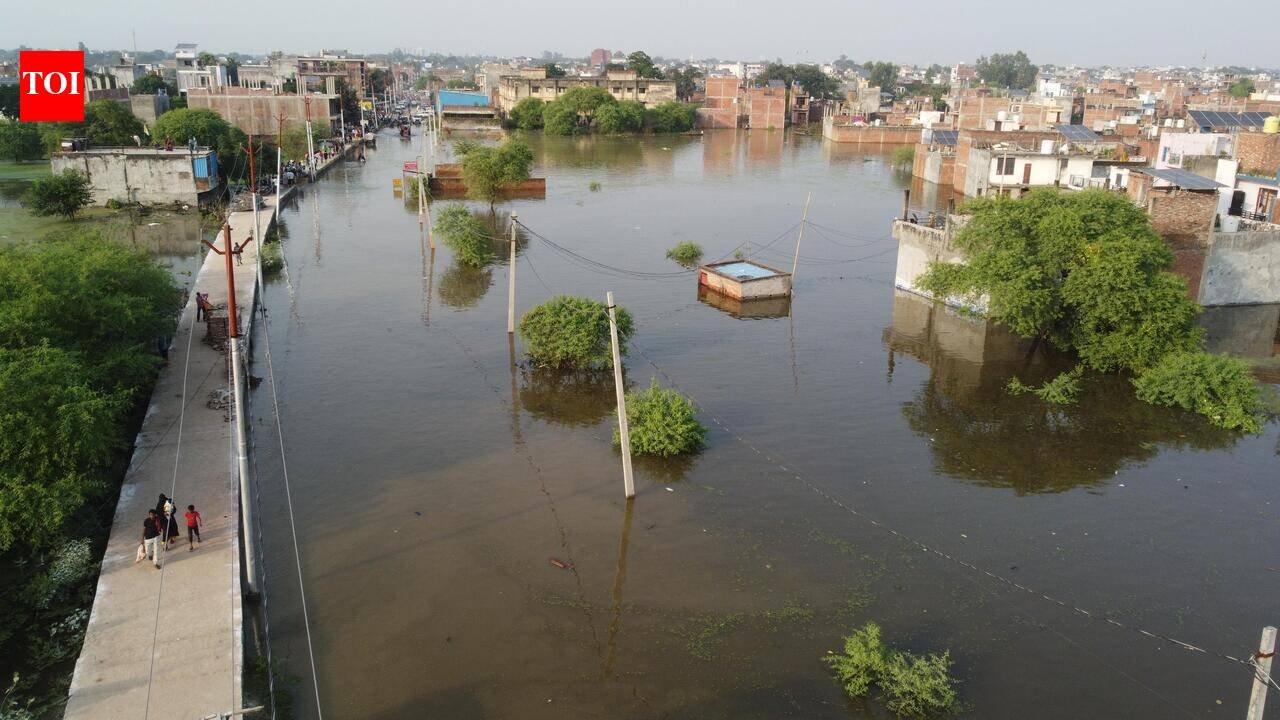
Every episode of urban flooding in Lucknow brings familiar explanations: unprecedented rainfall, climate change, overflowing drains and the inability of the Gomti to carry excess water. These factors matter, but they cannot explain the entire crisis.The more uncomfortable question is: what have we done to the river, its floodplain and the city’s natural drainage system? The river and its floodplain are not open space that can be forced to accommodate every development project. It is a dynamic hydrological system. Floodwater needs space, and the natural landscape provides that space through floodplains, wetlands and interconnected drainage networks.When these vital spaces are occupied or fragmented, flooding becomes more likely and its consequences more severe. We cannot destroy a city’s natural flood-management system and then blame the rain.The Gomti River has flowed through this landscape for centuries. Its river terraces, floodplains, ponds, wetlands and drainage networks evolved to carry, convey and store water. Yet the newer settlements and township development projects have progressively occupied and fragmented these vital spaces.The Gomti River serves as a primary drainage channel for several upstream districts, including Lucknow, Pilibhit, Lakhimpur Kheri, Shahjahanpur, Sitapur, and Hardoi. It is fed by 185 tributaries, 35 of which are major streams.Previously, various govt departments jacketed the riverbanks and constructed embankments that blocked numerous natural drains. A river requires space to convey and discharge water; this is a natural process that indirectly yields economic benefits worth billions of rupees through ecosystem services. The river’s entire valley profile has been drastically altered.Flooding in upstream areas like Faizullaganj, Manjhi, and BKT is a direct consequence of the development activities within the floodplain, specifically embankments and projects that have constricted the width available for floodwater flow; this is not a natural flood event.Yet, ironically, despite this man-made flooding situation, approval has been granted for the construction of more embankments. Subsequently, the reclaimed land is slated for use in real estate, parks, or commercial zones.Determining the minimum distance between embankments should be based on the river’s peak discharge and water-carrying capacity, rather than on how much land can be appropriated from the river for real estate and residential settlements.In recent years, many smaller streams have been encroached upon or fragmented leading to flooding even in short duration rains. Our studies have shown that more than 70% of Lucknow’s lakes and ponds have been encroached, yet the land authority remains largely occupied with high-end commercial areas and apartments.Numerous housing colonies and major development projects have been planned, but hundreds of unauthorized and unplanned settlements have continued to mushroom across the city. Ponds and wetlands have been encroached upon, while natural drainage channels have been obstructed or narrowed.This is not merely a failure of urban design; it raises serious questions about land-use regulation, enforcement and institutional accountability.Observations during Oct 2026 flooding in Lucknow raise important questions. In several locations, areas beyond the natural river terrace remained dry while water accumulated within or behind the constrained river corridor. Such patterns warrant scientific investigation into the effects of floodplain engineering, embankments, roads and obstructed drainage pathways.Compared to earlier floods, the flood of Oct 2026 in Lucknow is unique in many senses. The flooding happened not due to rain in Lucknow, but rain in the upstream districts of Pilibhit, Lakhimpur Khiri, Shahjhanpur and Sitapur.Gomti levels soared quietly but steadily in response to contributions from the tributary streams. The impact was seen almost one week after the rain when water level started to rise from Oct 2. The discharge was also much less than the 2008 flood but impacted more than 1,00,000 people with 40,000 houses partially submerged.On Oct 7, 2026, the discharge was about 25,000 cusecs with water level at 107.30 metres at Hanuman Saetu, which was almost one metre below the warning level of 108.50 metres.However, this was enough to flood the low-lying settlements such as Faizullaganj, Ghaila, Mama Colony, Daud Nagar, Millat Nagar, Jehta, Saitha, Hayat Nagar, Munna Lal Khera, Umrai Khera and Lohramau. These settlements are located in the Khadar area of the Gomti where periodic flooding affects settlements during overbank flow events.The district administration deployed 52 boats in the flooded areas to transport people and deliver relief materials. LDA intensified drainage and relief work around Ekana Stadium, Phoenix Palassio Mall and Sector 7 of Gomti Nagar Extension where Gomti water entered through the embankments.More than 30 pumps were deployed to drain out water. The prolonged inundation is the result of several factors acting together – with encroachment on natural floodplains as the major factor. Numerous projects have come up on Gomti’s active floodplain, obstructing the river’s natural capacity to spread across its banks forcing water levels to rise within the channel.Apart from several pumping stations, LDA has proposed 12 additional pumping stations along the embanked river between IIM Road and Kisan Path. Pumping stations can be essential in low-lying areas, but why must the city increasingly depend on power-guzzling pumps to remove rainwater that once moved through natural drainage pathways?Roads, bunds and embankments built across drainage corridors create hydraulic barriers. During intense rainfall, water accumulates behind these bunds, gravity drainage becomes difficult, and pumping becomes necessary.First, we obstruct the natural movement of water; then we spend huge money pumping away the consequences. A pumping station can remove water and alleviate waterlogging.A drain can convey water. An embankment can hold water. But none can replace a river, wetland or floodplain. Every proposed station should be assessed alongside the hydraulic effects of the roads, embankments and developments that make pumping necessary.HISTORIC FLOODS THAT LUCKNOW WITNESSEDLet’s visualise the historic floods that Lucknow witnessed in the past. The city saw major floods in 1854, 1870, 1871 and 1891.In 1871 during the rains, the river at the Lucknow railway bridge was 180 metre wide and 12.5 metre deep. The water moved fast with a velocity of 5.8 km/hr with an extreme discharge of 34369 cubic feet per second (cusec).Then came the record flood of 1894, when on the Sept 13, the Gomti in Lucknow rose to 2.13 metre above the normal high flood level of 108.81 metre. The maximum discharge was 234000 cusecs, which is almost ten times the discharge recorded on Oct 7, 2026.The roads by the river were totally submerged and the water level was one foot above the ball-room floor of the Chhatar Manzil. No other floods of such magnitude happened after 1894.The 1894 flood was the outcome of continuous rain from Sept 5-7 in Lucknow and districts upstream.In 1923, Lucknow experienced another record flood that inundated several low-lying settlements. Gomti River overflew its banks, submerging many parts of the old city, civil lines and cantonment. The peak discharge was about 75000 cusecs.The 1960 flood is one of the worst floods in Lucknow’s history. It was also caused due to excessive rainfall in the upstream districts. The river also received additional water from its several tributaries, including the Sarayan, Kathina, Kukrail and Sai.The peak discharge was recorded as 125000 cusecs that submerged almost half of the city under several feet of water. Residents were confined to the first floors and boats were deployed for rescue and transportation. Army units patrolled on boats in the flooded area and distributed food and other relief materials.The 1971 flood was the third highest on record in Lucknow, with a discharge of 107000 cusecs. On Sept 8,1971, the low-lying settlements were underwater. The river rose about 1.8 metres above the danger mark. Floodwater submerged several parts of the city under three to four feet of water, affecting Hazratganj, Narhi, Daliganj and nearby residential areas.The govt deployed the army to repair the embankment breaches and rescue stranded residents. More than 25,000 people were evacuated within 24 hours and sheltered in 18 relief camps. Elephants, boats and helicopters were used to support transportation, evacuation and relief operations.The flood also threatened animals at the Lucknow Zoo, where some were moved to raised platforms and protected with sandbags and boulders.The 1985 flood was also historic when the river rose to 109.50 metres with a peak discharge of 74000 cusecs.The 2008 flood occurred in the last week of Aug after heavy rainfall in Lucknow and upstream areas pushed the Gomti above its danger mark of 8.5 metres. The water level at Gau Ghat was recorded at 109.97 metres with peak discharge of 42,019 cusecs. On Aug 28, the level at Hanuman Setu was 108.99 metres, affecting over 1,00,000 people and claiming at least 15 lives. The flooding was aggravated by Lucknow’s fragmented drainage system, which could not cope with stormwater runoff, particularly where natural drainage channels had been obstructed and wetlands encroached upon.CONTRADICTION IN FLOODPLAIN POLICYThe problem extends beyond Lucknow. On Aug 7, 2026, the Ministry of Jal Shakti issued the River Ganga (Rejuvenation, Protection and Management) Authorities (Second Amendment) Order, 2026, published in the Gazette on Aug 10.The amendment introduced the category of an active floodplain, defined with reference to a one-in-five-year flood, and divided the broader floodplain into active, regulatory and warning zones, extending through the 100-year flood extent. It also removed the earlier reference to a ‘construction-free zone’ from the relevant provisions. These changes raise serious concerns about the future protection of river space and the scope for development in flood-prone areas. Removing an explicit construction-free safeguard and relying on zonal regulation creates legitimate questions about how effectively vulnerable river spaces will be protected.At a time when cities need to restore wetlands, protect their drainage systems and give rivers adequate space, weakening clear safeguards against construction risks moving policy in the opposite direction.For the Gomti, this concern is particularly significant. The river has already experienced substantial urban modification, including the restriction of portions of its floodplain through riverfront development.The priority should be to protect the remaining floodplain and restore hydrological connectivity, and not to create further pressure for construction.DEVELOPMENT AT WHAT COST?Development agencies are capable of planning high-end apartments, commercial areas, roads and major infrastructure. Yet unplanned settlements continue to expand, often in vulnerable locations.The consequences are borne disproportionately by people living in low-lying areas, including those with the fewest resources to recover from flooding.This is not an argument for blaming vulnerable communities alone. Authorities must investigate who controls the land, who authorises or tolerates illegal construction, who changes land use, and who allows natural drainage systems to disappear.Unauthorised occupation cannot be addressed fairly or effectively without examining the institutions responsible for preventing it.RESTORE RIVERS NOT DRAINAGE MACHINERYLucknow needs a comprehensive inventory and legal protection of its remaining ponds, wetlands, and natural drainage channels. Floodplain delineation must be based on hydrology, geomorphology and historical inundation, rather than development convenience.Major infrastructure projects must demonstrate their effects on flood conveyance, groundwater recharge and water storage before approval.The city must also assess the cumulative impacts of development projects, roads and surrounding urban expansion. No single project should be examined in isolation from the river system it modifies.The choice before Lucknow is clear: continue spending public money managing the consequences of ecologically unsound development or restore the natural systems that have regulated water for centuries.The Gomti is not flooding Lucknow. The land authority must accept how its own development decisions have increased flood risk. The next flood should not be treated as an emergent natural disaster when the underlying causes are visible in our land-use planning and floodplain encroachment.(Writer is a professor and head of the department of environmental science at BBAU. He has extensively worked on river and drainage systems and their restoration. Views are personal)
